East County Magazine
SDG&E PLAN TO CUT POWER GETS FROSTY RECEPTION AT PUC HEARING; BACK COUNTRY RESIDENTS, PUBLIC OFFICIALS VOICE OBJECTIONS
Printer-friendly versionBy Miriam Raftery November 2008 (San Diego) — Public officials and backcountry residents leveled harsh criticism at SG&E during a public meeting of the California Public Utilities Commission (CPUC)
FIRE OFFICIALS SAY SHOCKEY FIRE CAUSE CAN’T BE DETERMINED; PRAISE CAMPO RESIDENTS FOR SAVING HOMES
Printer-friendly versionBy Miriam Raftery Cal Fire Captain Richard Stephan October 27, 2008 (Campo) – The cause of the Shockey Fire, which burned approximately 400 acres on October 15, will likely
THE RENO REPORT: MORNING HAS BROKEN
Printer-friendly versionBy Jamie Reno Exclusive for East County Magazine October 15, 2008 (Tierrasanta) – Morning has broken. As the sun rises over the East County, a sense of calm permeates
HIGHWAYS OPEN, FIRES 100% CONTAINED IN CAMPO AND RANCHO BERNARDO; FIREFIGHTERS STILL BATTLE JULIET BLAZE
Printer-friendly versionOctober 14, 2008, 11:00 p.m. — All major highways in San Diego County are open tonight. The Juliet Fire, which burned 3,980 acres in the Oceanside area after spreading
NEW FIRES BREAK OUT IN RANCHO BERNARDO AND OCEANSIDE, I-5 CLOSED
Printer-friendly versionOctober 14 (12:30 p.m.) – Santa Ana winds are fueling new fires in several portions of San Diego County, forcing closure of several major highways and evacuations in the
FIRE NEAR CAMPO 50% CONTAINED, HWYS 94 AND 8 CLOSED, 400 EVACUATED
Printer-friendly versionOctober 13 (Campo) 9:30 a.m. — Three hundred homes have been ordered to evacuate due to a 100-acre wildfire that began at Highway 94 near Shockey Truck Trail. The
4,000 FLEE FIRES IN PENDLETON, OCEANSIDE, FALLBROOK
Printer-friendly version Fire in North County. Photo by Corina Squires October 14 (Camp Pendleton) 12:10 p.m. – The third blaze in there weeks to strike Camp Pendleton has charred over
SDG&E THREAT TO CUT POWER DURING FIRE DANGER SPARKS HEATED OUTCRY AMONG EAST COUNTY RESIDENTS
Printer-friendly versionLarge crowd likely at CPUC meeting Tuesday in San Diego By Miriam Raftery October 13, 2008 (San Diego’s East County) – Backcountry residents are reacting with shock, praise and
HIGH FIRE DANGER, SANTA ANA WINDS STARTING TONIGHT
Printer-friendly versionCAL Fire gears up with extra airpower, asks homeowners to take defensive steps; SDG&E may cut power in high-risk areas Story and photos by Miriam Raftery October 12, 2008
A FIERY ARGUMENT
Printer-friendly versionFire Chief, City and County leaders debate pros and cons of fire tax By Miriam Raftery 2007 San Diego wildfires destroyed over 3,400 structures and killed 15 people (photo:
Search by Specific Date
Support community news in the public interest! As nonprofit news, we rely on donations from the public to fund our reporting — not special interests. Please donate to sustain East County Magazine’s local reporting and/or wildfire alerts at https://www.eastcountymedia.org/donate to help us keep people safe and informed across our region.
Our Emergency Alerts Are Powered By:
This vital service is made possible by community partners
committed to public safety.
Info During a Disaster
DURING AN EMERGENCY
San Diego County Emergency Updates
San Diego County Office of Emergency Services
Alert San Diego: local emergency help
Statewide Fire Updates
Cal Fire info on fires in California
Cal Fire map: incidents statewide
Nationwide Wildfire Updates
Inciweb: maps wildfires in U.S.
Watch Duty App: live updates on fires in U.S.
Emergency Alerts (sign up!)
Alert San Diego: County alerts
Watch Duty App (online)
Watch Duty App (phone app)
East County Wildfire & Emergency Alerts
Evacuation maps
San Diego County emergency map
San Diego County Evacuation Planning
Emergency phone numbers
2-1-1 San Diego (24-hour disaster info)
Local police and sheriff contacts
County General Info: 858-694-3900
Report an emergency: Call 911
Traffic updates
CHP Traffic Incidents: Choose Border region top left
Utilities: Power Outages and Emergencies
Report a gas leak:
Call 911 or 1-800-611-7343
Weather
National Weather Service San Diego
Webcams
After A Disaster
Fire Safe Council: Post Disaster Recovery Red Cross:
Protect Your Community
Our Emergency Alerts Are Powered By:
Info During a Disaster
LIVE UPDATES

LEMON GROVE NONPROFITS UNITE FOR LOS ANGELES FIRE RELIEF FUNDRAISER
Printer-friendly versionEast County News Service February 10, 2025 (Lemon Grove) – On Saturday, February 1, the spirit of community and compassion was on full display as Lemon Grove nonprofit organizations joined

STATE FARM ASKS FOR MORE INSURANCE RATE INCREASES AFTER LA FIRES
Printer-friendly versionBy Levi Sumagaysay, CalMatters CalMatters is a public interest journalism venture committed to explaining how California’s state Capitol works and why it matters Photo: The Eaton Fire burns in the community

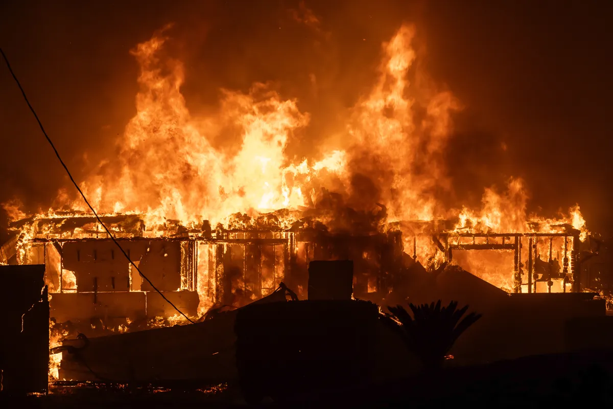
PHOTOS OF THE WEEK: BORDER 2 FIRE
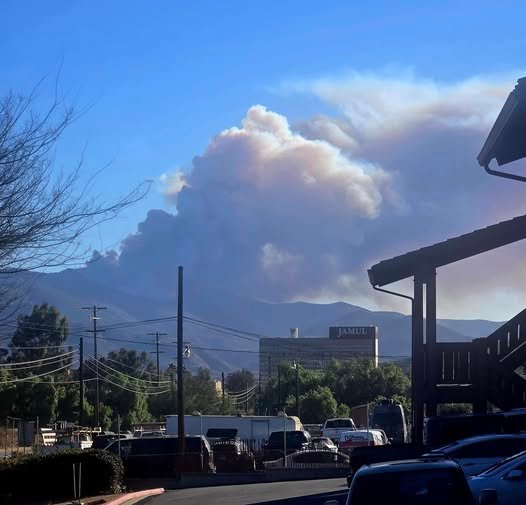
Printer-friendly versionEast County News Service January 28, 2025 (Jamul) — Robert Hobbs sent in these images of the Border 2 Fire, which burned over 6,500 acres after starting on Otay

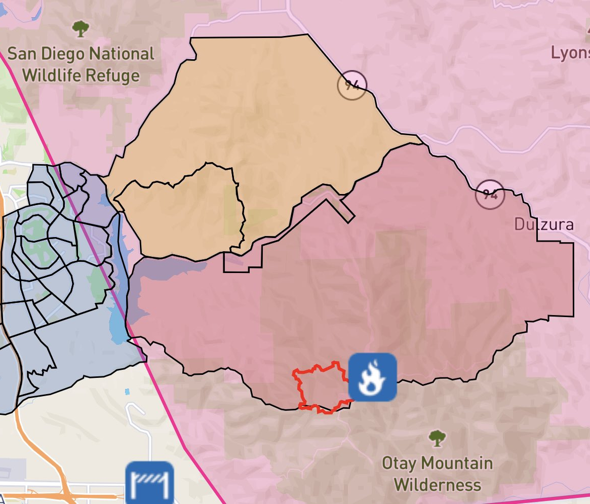
CAL FIRE HOLDS BORDER 2 FIRE TO 6,625 ACRES AS RAIN AIDS EFFORTS, BUT MUDSLIDES ARE POSSIBLE RISK
Printer-friendly versionBy Miriam Raftery Photo courtesy of Cal Fire Update January 30,2025 10 a.m.– All evacuation orders have been lifted. The fire is 100% contained. Update January 29, 2025 9

WATER CONSERVATION GARDEN OFFERS FREE HAVEN FOR BORDER FIRE EVACUEES AND PETS
Printer-friendly version East County News Service January 25, 2025 (Rancho San Diego, CA) — In light of the ongoing evacuations at the Border Fire, the Water Conservation Garden on the

SDG&E RESTORES POWER TO ALL CUSTOMERS AFTER HISTORIC WEATHER EXTREMES
Printer-friendly versionSource: SDG&E January 25, 2025 (SDG&E) – San Diego Gas & Electric (SDG&E) announced this evening that power has been fully restored to all customers affected by recent Public

EVACUATION AREAS EXPAND IN BORDER FIRE; EVACUATION CENTER AT CUYAMACA COLLEGE
Printer-friendly version Update January 25, 2025- The fire had modest growth overnight and is now 6,500 acres, per Cal Fire. Update 8:15 p.m.– Per CalTrans, State Route 94 is closed

EVACUATIONS ORDERED AS BORDER 2 FIRE BURNS THOUSANDS OF ACRES
Printer-friendly version Update 12 p.m.: Cal Fire has mapped the fire at 5,389 acres. It remains 10% contained. View laetst evacuation areas, whcih have expanded, here: https://app.watchduty.org/i/41110 By Miriam Raftery January

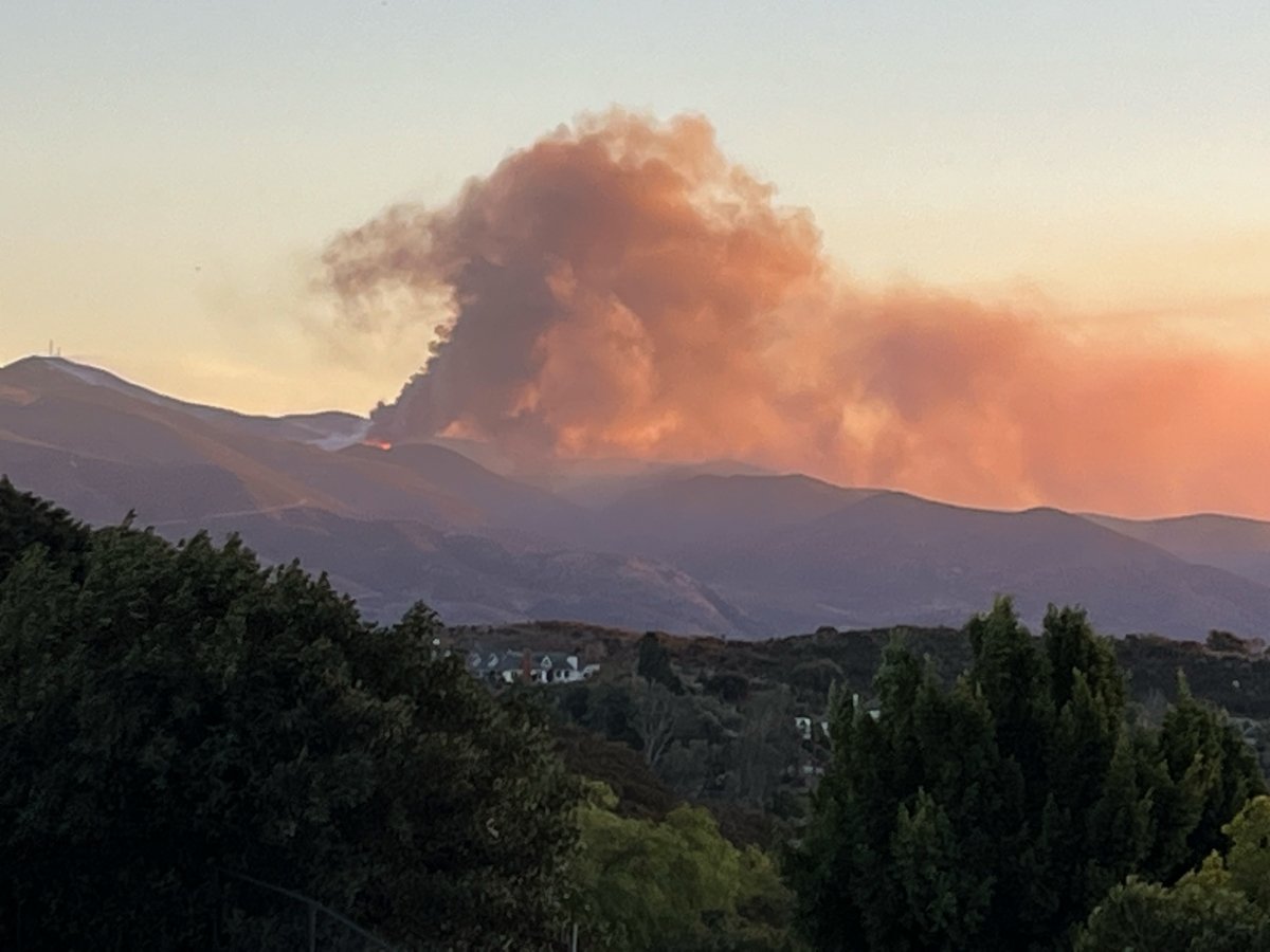
BORDER 2 FIRE VISIBLE ACROSS COUNTY, STILL WITH NO CONTAINMENT
Printer-friendly version Update 8:46 p.m.– The fire is now 600 acres, per Watch Duty App. No structures are currently threatened. By Miriam Raftery Photo, left, by Jeff Caton, taken from

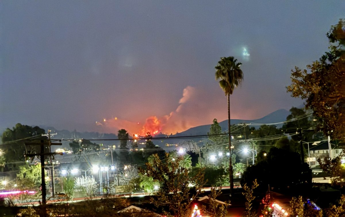
BORDER 2 FIRE ON OTAY MOUNTAIN SPREADING AT “DANGEROUS” RATE
Printer-friendly version Update 5:05 p.m.– The #Border2Fire is now 248 acres and still 0% contained. Winds have shifted toward campgrounds with campers at Pio Pico told to evacuate and Thousand
️ Official Evacuation Zones & Road Closures
Cal Fire Map
Watch Duty Map
Keep This Service Free
DURING AN EMERGENCY
San Diego County Emergency Updates
San Diego County Office of Emergency Services
Alert San Diego: local emergency help
Statewide Fire Updates
Cal Fire info on fires in California
Cal Fire map: incidents statewide
Nationwide Wildfire Updates
Inciweb: maps wildfires in U.S.
Watch Duty App: live updates on fires in U.S.
Emergency Alerts (sign up!)
Alert San Diego: County alerts
Watch Duty App (online)
Watch Duty App (phone app)
East County Wildfire & Emergency Alerts
Evacuation maps
San Diego County emergency map
San Diego County Evacuation Planning
Emergency phone numbers
2-1-1 San Diego (24-hour disaster info)
Local police and sheriff contacts
County General Info: 858-694-3900
Report an emergency: Call 911
Traffic updates
CHP Traffic Incidents: Choose Border region top left
Utilities: Power Outages and Emergencies
Report a gas leak:
Call 911 or 1-800-611-7343
Weather
National Weather Service San Diego
Webcams
After A Disaster
Fire Safe Council: Post Disaster Recovery Red Cross: